top of page
Search

Preparing for Alaska: The Pacific Northwest (plus a Lookback to Moab)

  • Writer: Alison (No Fixed Address)
    Alison (No Fixed Address)
  • May 27, 2025
  • 5 min read

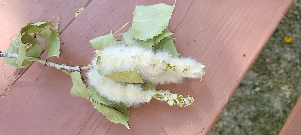
It's cottonwood time in the Pacific Northwest. Fluffy white clumps of seeds float through the air and gather in drifts alongside the roads. Around American Lake by our campground, tall, fluttering cottonwood trees are shedding their seeds into the breeze.


We're in the Seattle-Tacoma area of Washington State, making final preparations for our four-month trip into Alaska through Canada. We began earlier this year by having the rig's exterior ceramic-coated and all six tires replaced and aligned while we were in Palm Desert, California. In early March, Alison replaced the CO2/propane gas detector. (This was at four a.m. one morning when the every-few-days "replace-me" beep transformed to a constant alarm! Fortunately, we had purchased the part a couple of days earlier.) While settled into the Portland, Oregon area from mid-March through late May, we had engine maintenance and various minor rig repairs completed; updated our in-dash audio/display system from Soundstream to Kenwood (the old system had been losing functionality each year, including never being able to accept our cell phones' Bluetooth signals, and when it could no longer even hold onto the correct clock time, we knew it was finished!); and had our AGM lead-acid coach battery upgraded to a lithium-iron-phosphate 300 Ah (amp hour) battery plus DC-to-DC charger. We're hoping to be able to boondock in the north for a few days at a time with this upgrade!


Alison had started researching whether RVs could drive to Alaska when we first began contemplating a full-time RV life, some seven years ago. Because we would want to fully immerse ourselves in the experience, and we anticipated long stretches with little or no internet, we planned to wait until after both our retirements. Doug retired a couple of years ago; Alison finally retired this January. The time had finally arrived!


We ordered the annual "MILEPOST", a paperback guidebook to every mile of the roads that RV travelers use through Canada and within Alaska. After hashing out several possible itineraries, we roughed out a route that included both driving and taking our rig on ferries:


Our itinerary:  Washington State > British Columbia > Yukon Territory > Fairbanks > Denali State Park > Anchorage (including a flight to Arctic Circle/Utqiagvik/Beaufort Sea, not shown) > Kenai Peninsula > Denali National Park > Alaska/Yukon Territory > Inside Passage (via ferries) > British Columbia/Alberta > Lower 48.  (Prepared with Google My Maps)
Our itinerary: Washington State > British Columbia > Yukon Territory > Fairbanks > Denali State Park > Anchorage (including a flight to Arctic Circle/Utqiagvik/Beaufort Sea, not shown) > Kenai Peninsula > Denali National Park > Alaska/Yukon Territory > Inside Passage (via ferries) > British Columbia/Alberta > Lower 48. (Prepared with Google My Maps)

And now we could leave more room for spontaneity in our travels than we could in our first five years. We did make reservations for an "RVing to Alaska 2025" Rally at Denali State Park in July and for a campground in Denali National Park in August. We've reserved a flight tour to the Arctic Circle village of Utqiagvik (fka Barrow), and have scheduled or reserved times in Anchorage, Fairbanks, and Juneau to accommodate flights to and from the Lower 48. (Our younger daughter will be traveling with us the first month, and will need to fly back to Florida; our older daughter and her boyfriend will meet us in Anchorage for a few days in July; we will fly to Portland, Oregon for a summer gathering with Doug's family; and Alison's best friend from college will meet us in Juneau for a week in August.) Otherwise, we will be traveling as little or as much on any given day as we feel like, based on wildlife sightings, scenic views, and road conditions such as frost heaves and dirt or gravel surface. We will also be keeping an eye on the volcanic Mt. Spurr (80 miles west of Anchorage, showing some signs of unrest) and the wildland fire season activity.


Our hope is to post once a week from our adventure over the next four months!


Looking Back: June 2024, Moab, Utah


Cottonwood twig, Miles City, Montana, July 2021.  (All pictures by author)
Cottonwood twig, Miles City, Montana, July 2021. (All pictures by author)

As with the lake we are currently camped by in the Pacific Northwest (and other waterways throughout much of the U.S.), the Colorado River that runs through the canyonlands near Moab, Utah was once lined with native cottonwood trees. As we learned on our half-day rafting/kayaking trip on the river (Mild to Wild Rafting), the invasive tamarisk tree has supplanted most of these Colorado River cottonwoods. First imported from Eurasian countries as an ornamental shrub or windbreak tree in the 1800's, the tamarisk was further utilized to stabilize riverbanks, especially after dam-building, in the 1900's. Unfortunately, it outcompetes native vegetation, sucks up to 300 gallons of water per day from the river, and offers little nourishment or habitat to native wildlife.


Tamarisk trees lining the Colorado River near Moab, Utah.

More uplifting sights on our June 2024 Colorado River trip included adrenaline-spiking rapids, fantastical rock formations, and flitting Cliff Swallows. A torrential rain and hail storm swept in only after we had made it back to the outfitter station, thank goodness!


Doug kayaked and Alison rafted on the Colorado River near Moab, Utah.

We walked our e-bikes through the rock-strewn road after a short but torrential storm in Moab, Utah.

The next day, we rode our e-bikes through a much more peaceful scene.  (Moab, Utah)
The next day, we rode our e-bikes through a much more peaceful scene. (Moab, Utah)

The uranium mining boom of the 1940s and '50s left behind contaminated tailings and soil next to the Colorado River near Moab, Utah, that are being excavated and transported by special train to the Crescent Junction disposal site, some 30 miles north.

Ancient petroglyphs...

...and modern-day rock climbers abound in Moab, Utah.

We also drove through Arches National Park, stopping at several famous arch formations, created when tiny fractures in the sandstone are expanded by water seeping, freezing, and melting, forming first fins and then holes and, eventually, a collapsed arch. If there are both harder and softer sandstone types, a "balanced" rock may occur instead.


Doug on the trail to Skyline Arch, Arches National Park, near Moab, Utah.

Another of the many arches at Arches National Park, near Moab, Utah.

The Balanced Rock formation, Arches National Park, near Moab, Utah.

For the nearby Canyonlands National Park, we took a 4x4 overland tour (NAVTEC Expeditions) of the area just outside and within the park.


The majesty of the Canyonlands encompasses layers of land formed over the last 300 million years, and skies that re-form every minute, near Moab, Utah.

Potash mining evaporation ponds, dyed bright blue, just outside Canyonlands National Park near Moab, Utah.

Ranchers used the Canyonlands as winter pasture for their herds, prior to its becoming a National Park.  Our guide took us to a historic cowboy camp - little more than fencing for the cattle, and a wooden shed for the cowboys to sleep in.  (Near Moab, Utah)
Ranchers used the Canyonlands as winter pasture for their herds, prior to its becoming a National Park. Our guide took us to a historic cowboy camp - little more than fencing for the cattle, and a wooden shed for the cowboys to sleep in. (Near Moab, Utah)

The views on our Canyonlands tour were spectacular.  (Near Moab, Utah)
The views on our Canyonlands tour were spectacular. (Near Moab, Utah)

A closer look reveals black patches of biological soil crust, a delicate mixture of cyanobacteria, microfungi, and algae, which then support moss and lichen, and then small plants.  Our guide warned us to watch our step, as a misplaced footfall can destroy fifty or more years of slow growth.
A closer look reveals black patches of biological soil crust, a delicate mixture of cyanobacteria, microfungi, and algae, which then support moss and lichen, and then small plants. Our guide warned us to watch our step, as a misplaced footfall can destroy fifty or more years of slow growth.

The hardy juniper tree utilizes a deep tap root, a network of lateral roots (often exposed as they grow toward a source of moisture), and a self-pruning feature to survive in the dry climate.  (Canyonlands National Park, near Moab, Utah)
The hardy juniper tree utilizes a deep tap root, a network of lateral roots (often exposed as they grow toward a source of moisture), and a self-pruning feature to survive in the dry climate. (Canyonlands National Park, near Moab, Utah)

A rainbow over Canyonlands National Park, near Moab, Utah.


Comments


  • instagram
  • Facebook

©2025 by No Fixed Address Travels. Proudly created with Wix.com

bottom of page