
Alaska: Anchorage and Utqiagvik
- Alison (No Fixed Address)

- 2 hours ago
- 7 min read

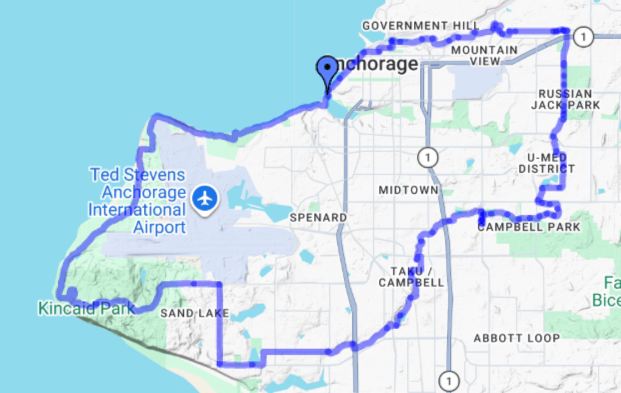
We reached the south-central coast of Alaska and the state's largest city, Anchorage, in July 2025. Anchorage holds about 40% of Alaska's population (about 289,000 in the city, and 117,000 in the surrounding area, out of a total state population of about 739,000 people).
Humans arrived in the region after the last Ice Age, perhaps 12,000 years ago. Europeans began exploring the area in the second half of the 18th Century, with Russians establishing outposts (though native Dena'ina people destroyed at least two of those and resisted others being established), and British explorers, including British Royal Navy Captain James Cook, mapping the area. (Hence the name of Cook Inlet, which extends inward from the Gulf of Alaska and further branches into Knik Arm and Turnagain Arm at what would become Anchorage.) In the mid-1800s, smallpox devastated the Dena'ina; in 1867, the U.S. purchased Alaska from Russia, and American trading stations and gold-seekers quickly followed. By 1898, however, gold-seekers had moved on to the Klondike Gold Rush in Canada's Yukon. Anchorage's founding and first real growth came in 1915, from a railroad built by the U.S. government from Seward (on the Kenai peninsula just south of Anchorage) to Fairbanks (in the interior of Alaska), primarily to transport coal from mines just north of Anchorage. Residents voted to name the new town Ship Creek, but the U.S. Post Office's use of "Anchorage" made that the town's de facto name. Anchorage's next boom came from military bases and missile testing sites during WWII and the Cold War. The discovery of oil in Prudhoe Bay in 1968 and the building of the Trans-Alaska Pipeline to Valdez (120 miles east of Anchorage) led to Anchorage becoming oil companies' corporate center, resulting in further growth. (Anchorage and Valdez are now major ice-free, dredged deep-water ports which handle containerized and bulk cargo and petroleum products.)

Anchorage was replete with activities! Walking around downtown, with its murals and local museums; the Anchorage Trolley Tour; biking and hiking trails; the salmon population in Ship Creek; the Alaska Botanical Garden and Alaska Zoo; and the Alaska Native Heritage Center.


A sculpture of a Dall sheep against a mural of fireweed and mountains; carved ivory displayed at the Anchorage Museum (cribbage boards have been carved by indigenous Alaskans into ivory and bone as souvenirs since commercial whalers introduced the game in the mid-1800s); a mural of marine life on the J.C. Penney building in downtown Anchorage, Alaska.


Anchorage is full of flowers in the summer (the city plants some 80,000 of them): Flowers adorn the 1955 log cabin that now serves as the Visitor Information Center; the renovated and repurposed Railroad Freight Shed near our Ship Creek campground was delightfully enlivened with hanging baskets and containers of flowers.


Sights on the Anchorage Trolley Tour: Float slips at Lake Hood Seaplane Base, the largest in the world; Earthquake Park, commemorating the March 27, 1964, Good Friday Earthquake, caused by a 9.2 magnitude megathrust at the boundary of the North American and Pacific tectonic plates which triggered 4-1/2 minutes of shaking (here, the affluent neighborhood of Turnagain Heights slid 2000 feet down and left still-visible ripples in the earth), resulting in collapsed buildings, rock slides, and tsunamis (the highest was 220 feet near Valdez, but tsunamis reached throughout the Pacific Ocean as far as Antarctica), with 140 deaths and $116 million (in 1964 dollars) in property damage.


Doug joined a group bike ride of the Moose Loop, an interconnected 32-mile loop of mostly-paved trails, which happens to look like a moose's head looking west; on a separate e-bike ride, Doug and Alison saw sandhill cranes near the Knik Arm (they stay in the area from April to September to breed, then return to California for the winter).


Guided hike on Flattop Mountain Trail (elev. 3,510 feet, though only Doug summited it; Alison declined the final scramble): View to the west of Turnagain Arm, Kenai Peninsula, and Alaska Range; interior view of the Chugach Mountains from early in the trail; some of the trail was quite steep; interior view of the Chugach Mountains from near the summit (Chugach State Park, Anchorage, Alaska). The Turnagain Arm, which bounds the south side of Anchorage, has a mean tidal range of 30 feet, and daily exhibits a bore tide wave (water rushing back into a shallow, narrowing inlet) of up to 10 feet that takes about five hours to travel the 50-mile length of the Arm. (We did not manage to catch a glimpse of the bore tide during our Anchorage stay, alas!)


Salmon in Ship Creek, just north of downtown Anchorage: Salmon (probably Coho/Silvers in their pre-spawning silver) circling in a protected portion of the Creek, where their eggs will be collected and hatched for dispersal throughout South Central Alaska rivers; more protected salmon, probably Chinook/Kings in their spawning pink; fishermen try their luck in an open-to-fishing portion of the Creek; a fisherman leaving with his catch.


Beautiful but deadly monkshood (aka wolfsbane) at the Alaska Botanical Garden; a reindeer accepts a treat but afterward out-maneuvered the shot of medicine (behind the vet's back) at the Alaska Zoo; a mountain goat paws the dirt in a steep enclosure (as with reindeer, both male and female mountain goats have horns) at the Zoo; one grizzly (brown) bear locates a hidden treat while another (back right, in shade) continues to search. The Alaska Zoo is populated only by domestic, injured, or orphaned animals, and has a mission of conservation (Anchorage, Alaska).


A demonstration by local youth of indigenous games of skill involving a tethered ball; an example of a historical indigenous dwelling (Alaska Native Heritage Center, Anchorage, Alaska).
We also used Anchorage as a flight base, with two trips to gather with family in Oregon and Arizona, and one overnight tour past the Arctic Circle.


Downtown signpost of air miles to distant cities; a taxidermied moose greets visitors at the airport (Anchorage, Alaska).
Utqiagvik (fka Barrow), Alaska
We originally had scheduled our tour to the far north to travel with our older daughter and her boyfriend, but the Covid that we had picked up in Fairbanks precluded that. So, instead, our tour happened a couple of weeks after theirs.
Utqiagvik (pronounced OOT-kee-AHG-vik), an Inupiat placename derived from a word meaning wild roots or snowy owl (depending on whom you ask), was named Barrow by a British explorer in 1825. In 2016, a city referendum changed the name back to Utqiagvik.
At 71° Latitude, Utqiagvik is the northernmost city in the U.S., roughly 320 miles north of the Arctic Circle and 1,300 miles south of the North Pole. For about two months in the winter, the sun never rises; for about 2-1/2 months in the summer, the sun never sets.

While technically one could travel overland to Utqiagvik in the winter (Anchorage to Fairbanks on the paved Richardson Highway, Fairbanks to Prudhoe Bay on the gravel-surfaced Dalton Highway, Prudhoe Bay to Utqiagvik on ice roads and frozen tundra), generally people arrive by Alaska Airlines or bush plane, and cargo arrives by annual summer barge deliveries and by air.


Flying over the Brooks Range, which lies about halfway between Fairbanks and Utqiagvik, Alaska; flying over the summer tundra outside Utqiagvik, Alaska.
We stayed overnight at the Top of the World Hotel, and walked alongside the Arctic Ocean (dipping only our fingers into the icy water, unlike some teenage tourists who plunged fully in!) We also visited the Inupiak Heritage Center, where we learned about indigenous hunting of bowhead whales, and took a van tour of the town. Our indigenous tour guide was the son of one of the usual guides, who had had to travel to her home village for a family need. When Alison asked him his favorite part of growing up in Utqiagvik, he talked about hunting caribou and seals; his least favorite part had been school (often a universal answer among young people, no matter their background!)


A bowhead whale skull in town; a "fancy parka... made from rabbit ... Wolverine and calf skins... worn during special occasions, such as the annual community wide Nalukataq (blanket toss)..." that was created by a local indigenous Master Seamstress and is now displayed at the Top of the World Hotel. (The blanket toss is part of the June celebration of the end of the whaling season. A sort of hand-held trampoline of sewn-together skins was once used to give hunters momentary height to scan for whales or game; now it is used to demonstrate jumping and flipping skills.) (Utqiagvik, Alaska)


A snow fence protects the town from windblown drifts in winter; an old style of residence; newer residences; ATVs (and snow machines in winter) are everywhere in town. Buildings are elevated on stilts (not always visible) to keep from melting the permafrost beneath (Utqiagvik, Alaska).

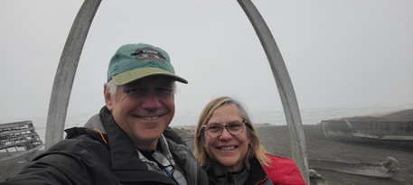


A selfie at the landmark whalebone arch signifying the "Gateway to the Arctic"; whalebone arches at the cemetery are reserved for whaling captains (Utkiagvik, Alaska).


Massive fuel tanks hold a year's worth of aviation and automobile fuels, brought in by barge each summer; pipelines from nearby natural gas fields now supply most of the town's heating needs, replacing the traditional sources -- whale blubber, seal oil, and driftwood (Utqiagvik, Alaska).


Meeting hall parking lot sign in English and Inupiak (indigenous Americans comprise about half of the population, and subsistence hunting and native traditions and celebrations are the foundation of the local culture); hospital sign in Inupiak and English (this is the only critical care hospital in the 10,000-person, 94,000-square-mile North Slope Borough of Alaska); produce price sign in the grocery store (prices are shockingly high compared to the lower 48, offsetting the higher pay available for public sector and oil field jobs filled by locals and by immigrant Filipinos and Pacific Islanders) (Utqiagvik, Alaska).


Comments